
How to Read the Kernow Way Surf Report
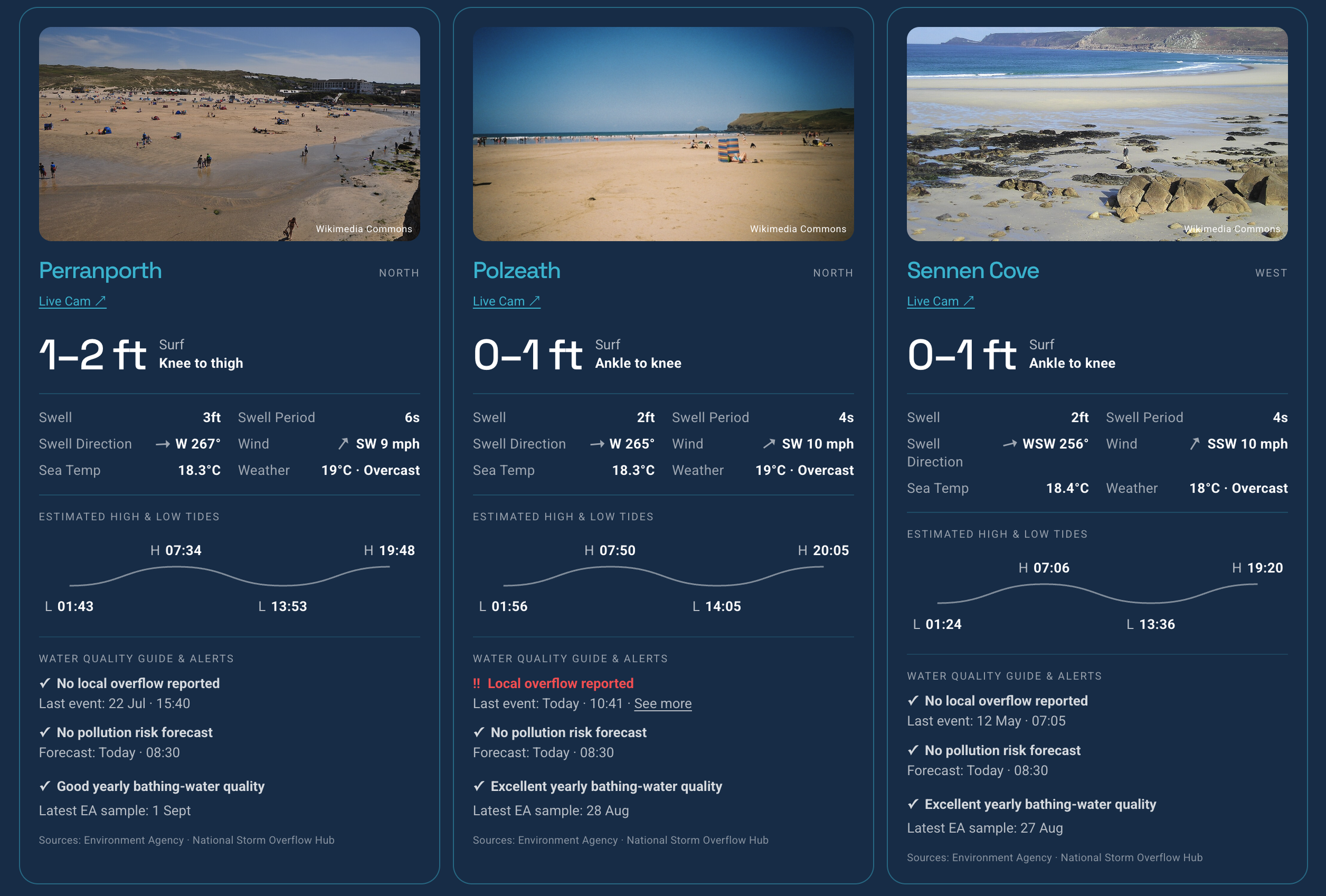
The Kernow Way Surf Report is a passion project built around a simple idea: bring useful information about Cornwall's beaches together in one place.
You don't need to understand every number in a surf forecast to know whether it's worth heading to the beach. Here’s a quick guide to what we show and what it means.
Review our surf and beach report https://www.kernow-way.com/surf
Surf — 2–3 ft
Our estimate of the breaking wave height at the beach. It combines modelled swell with swell period, direction and our calibration for each surf spot.
The body-height description underneath — Knee–thigh, Waist–chest, Head high — is simply another way of visualising the estimated surf size.
Swell — 4 ft
The height of the swell travelling towards the coast, before the shape and orientation of the beach affect it.
Swell height and surf height aren't the same thing. A 4 ft swell won't necessarily produce 4 ft breaking waves at every beach.
Swell Period — 12 sec
The time between waves in the incoming swell.
As a simple rule, a longer period usually means more powerful, better-organised swell. A 3 ft swell at 14 seconds can produce very different surf from 3 ft at 6 seconds.
Swell Direction — WNW
Where the swell is coming from.
Every beach faces a different direction, so the same swell can produce good surf at one beach and very little at another.
Wind — SW 14 mph
Where the wind is coming from and how fast it's blowing.
Offshore wind generally helps clean up the waves. Onshore wind tends to make them messier. What's offshore depends on which way the beach faces.
Sea Temp — 16.7°C
The modelled sea-surface temperature around the beach.
Weather — Temperature & Conditions
The weather section gives you a quick picture of what it should feel like at the beach, including air temperature and expected conditions such as sunshine, cloud or rain.
Weather conditions are forecast rather than observations taken directly at the beach, so local conditions can differ—particularly around Cornwall's exposed coastline.
RNLI Lifeguard Patrols
Where available, we show RNLI lifeguard patrol dates for the beach.
Patrols are seasonal and vary by beach and time of year, so always check the latest information and look for the red and yellow flags when you arrive. If you're swimming or bodyboarding at a lifeguarded beach, the RNLI recommends using the area between the red and yellow flags.
The patrol information is a useful guide, but conditions and lifeguard coverage can change.
High & Low Tides
Our estimated times for the day's high and low tides.
Tide can dramatically change how a beach breaks, so it's worth looking at alongside surf size and wind. These are planning estimates and should never be used for navigation.
Water Quality Guide & Alerts
✓ No local overflow reported means we haven't identified a recent storm-overflow event from monitored outlets within 2 km of the beach.
‼ Local overflow reported means a monitored outlet within that radius has reported an overflow. It doesn't necessarily mean the bathing water itself has been affected.
✓ No pollution risk warning means there is currently no Environment Agency pollution-risk warning for that bathing water.
‼ Pollution risk warning means the Environment Agency has issued a warning of an increased risk of reduced bathing-water quality.
✓ Excellent yearly bathing-water quality is the Environment Agency's annual classification of the designated bathing water. This is a long-term quality assessment, not a statement about conditions today.
Latest EA sample tells you when the Environment Agency most recently sampled the bathing water.
Put it all together
Don't judge a surf spot from one number.
A 3 ft swell + long period + favourable direction + offshore wind could produce much better surf than a larger swell arriving from the wrong direction with strong onshore wind.
That's why Kernow Way puts surf, swell, period, direction, wind, tide, sea temperature and water-quality information together in one place.
The numbers tell you what the models expect. The webcam tells you what's actually happening.
About the Surf Report
The report combines free local beach webcams, surf and marine forecast data, tides, sea temperature, Environment Agency water-quality information and local storm-overflow alerts. It's still evolving. Over time, we want to improve the forecasting side too — learning more about how swell height, period, direction, wind and local geography translate into the actual surf at individual Cornwall beaches.
The forecast tells you what to expect. The webcam shows you what's actually happening.
Review our surf and beach report
https://www.kernow-way.com/surf
